Archives

Rivers and Lakes were made, but…

…no pictures today because I made a muck up of trying to make the long rivers more curvy. <.<

Tomorrow I will trace the map and start clean with shiny new curvy rivers.

And some lakes, preferably ones that don’t look like a troll-head. Those old troll dolls with all the hair.

I keep forgetting you don’t need visible obvious rivers feeding into a lake (visible on a continent-scale map, that is). It could all be streams.

Pictures tomorrow!

(pre-curvied drawings can be shown here – https://twitter.com/lynthornealder/status/722939920877273088 – that at least decide placement of the rivers in broad scale)

Edit (again): Please ignore the awful scribbles that are the rivers. This is for basic city and border placement.

Image moved to http://wiki.lynthornealder.com/index.php?title=PortalBound_Maps 

Red is our story country, at least the beginning of it. Blue is Second Country and spills onto the large island below and 1/5 of the small islands. Third country is the other small islands and the last 2 largish islands. (Islands not visible on this map)

This entry was originally posted at http://aldersprig.dreamwidth.org/1092832.html. You can comment here or there.
Adding mountains to a fantasy map… with split peas~

After the lentil map yesterday, I wanted to add mountains next.

So back to the pantry!

Peas! I played with a few different ranges before deciding that before a water-raising event some 1000 years ago, much of this island chain was one continent. So many of the peaks (on the left of the map) are the remains of a single mountain range.

And here’s the map with the mountain ranges roughed in. Frankly, I think they show up better as peas <.<

Next, according to every “draw your fantasy map” thing I’ve found, is supposed to be rivers. But I am sort of wanting to know what the rest of the elevation is doing!

Like, are there gorges? (I live in NYS, we have a lot of gorges). Is there a broad bread-basket plain there along the bottom of the main continent? I originally imagined a N-S cross-continental river; where would that go?

Also, considering the scale, are my mountains too wide? I should look into mountains a bit more.

(ETA: from wikipedia: “The Rockies vary in width from 70 to 300 miles” Mine edge out about 200 miles wide, so I’m okay!)

(ETA: BIOMES I need to figure out BIOMES. Well, “need to.”)
(more editing: Rough Biome Map)

Images all moved to http://wiki.lynthornealder.com/index.php?title=PortalBound_Maps

So many things to think about!

Advice?

This entry was originally posted at http://aldersprig.dreamwidth.org/1091857.html. You can comment here or there.

Making a fantasy map with lentils~

First things first: hattip [personal profile] becka_sutton, for showing me this video.

This is my attempt at creating Yet Another Fantasy World via the “pile of stuff on the paper” method.

Images moved here.

First attempt: sort of a shark under the US. Not quite the look I wanted.

Second attempt: much closer.

Close-up of the lower islands.

And here’s the draft map!

Next up: Mountains

Edited to add: dimensions

//platform.twitter.com/widgets.js

And Atlantis:

//platform.twitter.com/widgets.js

(this is for the setting I’ve been working on for a story whose working title is Portal Bound)

P.S. North is to the right on all these. Not sure why the images insist on being rotated.

This entry was originally posted at http://aldersprig.dreamwidth.org/1090269.html. You can comment here or there.

Map – Another Preview

Originally posted on Patreon in March 2019 and part of the Great Patreon Crossposting to WordPress.

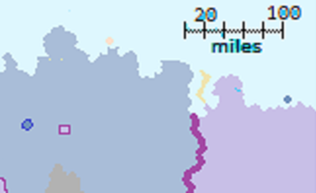
A little more about one of my current WIP maps – the one made in MS Paint.

We get to find out about three different nations in this little piece of worldbuilding!

A conlanging generated at https://www.vulgarlang.com/ because this is not a conlang project 🙂

🗺️

The northwestern corner of our map is – more or less – occupied by the nation of Shehix /ʃeˈhix/  – a word which in the language of the Shex people means Veranda.  At least, that is the most common meaning suggested, although it sounds very similar to a word which means taunting or We got ours.

In this map sector, we can see several things:

First, the border with Ūptī /ˈuːptiː/ – this border follows the Upti river and is one of the least-contested in the land.

Secondly, the Ūptīian Quarter, a rectangular section of Shehix which was ceded to Upti after the Skirmish Mess of 792.  It is said by the Ūptīian to mark the furthest spot they conquered in that Mess and by the Shex to be simply the furthest place an Ūptīian flag could have been found at that time.

Thirdly, we have the Farm Loss – a small circle of territory belonging to Klueyiskũ /kluˈejisku:/.

The Farm Loss was not the result of a war; instead it was a gift to the Klueyiskũi people after they proved instrumental in saving the Shex people from a particularly bad disaster when the Demon Winds came down from the northern water, destroying several towns and cities and wrecking the crops of 503 and, subsequently, 505 and 506.

The Klueyiskũi people were more than generous in that  crisis, and while the Shex paid back the loans of food and material over the next two centuries, the Farm Loss grant remains.

Seed for this language: 6072100918809586  – Shex
Seed for this language: 6863082975061514 – Upti
Seed for this language: 19840300364268204 – Shéltró, the language of the Klueyiskũi


Want more?